‘Never been anything like this’: Maple Ridge residents grapple with 224 Street flooding
Cities across the Lower Mainland come to grips with devastation following weekend storm
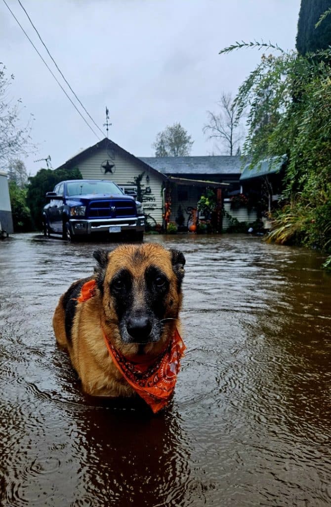
Julie MacMillan saw signs of the storm before it hit her property in rural Maple Ridge.
For 30 years, MacMillan has become accustomed to flooding on and off her property on 224 Street south of the Silver Valley neighbourhood.
“The flooding has happened here frequently for years,” said MacMillan, who grew up in West Vancouver but purchased a home on a couple acres in Maple Ridge to start a horse recovery and rescue company, J&M Acres.
The main road next to her property, 224 Street, normally goes under a bit of water a couple times per year. Her backyard floods quite often. And during her first winter in Maple Ridge, she had to bring a pig, which she received as a wedding present, into her home due to flooding.
“It’s a bit stressful but you get used to it after a bit,” MacMillan said.
But when she woke up the next morning, she knew this atmospheric river was different from the others, including the series that hit B.C. in 2021 and was later dubbed ‘the worst flooding event in provincial history’ by the Insurance Bureau of Canada.
Early Saturday morning, MacMillan noticed a driver stuck on the road, all three of her horses with water up to their fetlocks — the ‘ankle of a horse — and the fact that she couldn’t leave her home because of the volume of water outside.
“This was a whole different ballgame that was pretty crazy,” MacMillan said. “It’s never been anything like this.”
The source of excess water — be it snowmelt or heavy rainfall — is spillover from the nearby North Alouette River, a waterway that typically sees its tide increase dramatically during storms.
Last Friday night, MacMillan noticed the city put signs along 224 Street, indicating that the road would be closed ahead of an expected heavy storm. MacMillan tracked the storm ahead of the weekend, however, she said she thought Vancouver Island would bear the brunt of the hardest rainfall.
Maple Ridge, Coquitlam, and the North Shore ended up seeing a death of a local teacher, evacuations and one missing person in their respective communities due to mudslides and rain.
“My stress level went from nothing to 10 instantly, it crested and stayed for hours and hours of [being] one or two inches of leeway of coming into the house,” she said. “And that goes from inconvenience to disaster.”
Although MacMillan got through the storm relatively unscathed — minimal property damage and repairs on a bridge crossing a creek — she says the flooding is getting worse in her community.
“It’s definitely gotten way worse over the years,” MacMillan said.

Water depth in the North Alouette reached a peak of 113 inches at 132 Avenue and 224 Street last Saturday, the highest mark in that portion of the river in one year, according to a river gauge in the area.
Another nearby resident, who preferred not to be named, told The Ridge they have noticed flooding on their property or on 224 Street four times in the last three years, including twice in 2023.
In one of the incidents from last year, the water came about one foot into their house, according to the resident. They would like the city to physically alter the North Alouette River to make it deeper and avoid future floods.
However, they recognize that may cause harm to the fish habitat within the river.
The area around 224 Street, between Abernethy Way and 144 Avenue, is a known floodplain, the city wrote in an emailed statement to The Ridge. And it the event of extreme rain or snow events, nearby residents may be impacted.
Maple Ridge has taken steps over many years to reduce flood risks in the area.
Both the North and South Alouette rivers don’t have dikes and their flow rates are determined by the volume of rainfall. (BC Hydro can reduce flooding on the south river via a dam, depending on its storage volume and spillage capacity, the city wrote on its website.)
But bridges were reconstructed over both rivers between 2003 and 2013 to increase resilience against high river levels.
In 2016, Maple Ridge also commissioned a study to understand the flood risks in the Alouette River floodplain, roughly nine years after the largest flow event on the North Alouette River — 245 cubic metres per second — heightened concerns from residents.
The study identified a floodplain bounded by Park Lake, 236 Street, 127 Avenue and 136 Avenue. And outlined a number of flood management tools such as the creation of an early warning system, preparedness plan and vulnerability assessment, among other improvements.
The city issued a statement on Oct. 17, two days before heavy rainfall doused the region, warning residents about flood risks and high winds.
“In response to recent events and the area’s history, the city of Maple Ridge has undertaken several measures to mitigate flooding risks,” the city wrote, adding that it works provincial and federal forecasting groups to prevent flood damage, which may include preventative measures like sweeping drains and streets ahead of heavy rainfall.
Earlier this year, city crews also cleared debris from the North Alouette creek bed to reduce the risk of flood damage.
MacMillan doesn’t know what else the city can do to manage the flooding in a community she’s called home for about three decades.
She doesn’t want to move, retire or stop rehabilitating horses anytime soon.
In the days following the flood, multiple people visited MacMillan to help clean up her property, giving her a strong sense of community and appreciation for kind friends and neighbours in hard times.
But if they start coming over more frequently to help in the coming years due to flood damage, she may have to reconsider her future.
“I’m a little more laid back than most people,” she says, “but the day the house actually goes under, my tune will change a lot.”
Author